By Gigi Ragland
We drove past the summit and parked the vehicle. The wind was so fierce I could hardly stand let alone hop on a mountain bike. Windy conditions are not uncommon in the high mountains of the Andes especially the dry Altiplano of the Puna region where we had just come from. Relentless, the harsh dry climate challenges even the most hearty souls. And more than any other element, the mighty wind carves away and shapes the mountains. Alternatively, on the other side of the pass towards the Calchaqui Valley where we were headed, water erosion plays more of a factor in shaping the mountain environment.
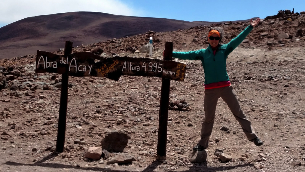
Hoping for calmer conditions, we got lucky. In our case, a few hundred feet on the other side of the summit made a huge difference on a “go” or “no-go” bike day. It was remarkable how the wind gentled from gale force to playfully windy. After final adjustments on the mountain bikes with jackets zipped up to our chins we were prepped and ready to descend Abra del Acay (16,059 feet), the highest mountain pass along the Argentine portion of the legendary Ruta 40. The Ruta 40, considered one of the best road trips in the world, runs parallel north to south of the Andes mountain range in Argentina for 3,340 miles. Before even taking off we knew it was going to be an epic ride—the kind of mountain bike ride that blows your senses away at each winding turn.
We were given an informative talk of the route and Andean/Inca history earlier that day by our main guide, Ana Ines Figueroa, founder and managing director of Adventure and Landscape. She developed our itinerary based off of her tour company’s Salt & Wine trip collection that combines the salt flats in the Puna region with the altitude wines from the Calchaquí Valley. All of which we had the privilege of experiencing. But this part of the 6-day trip, well, it was a showstopper. How many times in your life do you get to bike an ancient road accessed for thousands of years from an elevation of 4,895 meters (16,059 feet) into a valley dropping down to 3,015 meters (9,892 feet)?
The Ruta 40 section we cycled was also a part of the Qhapaq Ñan, or Main Andean Road. Designated a UNESCO World Heritage Site in 2014, the Qhapaq Ñan, took the Inca’s centuries to build demonstrating the vast reach of the civilization from Ecuador, Peru, Bolivia, Chile to Argentina. A well-traveled route for hundreds of years, the Main Andean Road was used for defense, communication and trade by the Incas then later by 15th-century Spanish conquistadors in search of silver routes. Today, it continues to be a lifeline into Andean/Inca culture in South America.
A little nervous and excited, like skittish horses chomping at the bit, our small, gutsy group of female travelers sped out onto the dusty dirt road. Faded lines from the original Main Andean Road could be seen on the mountain slope connecting to the road near our starting point. It was thrilling to think we were cycling on a road used for centuries via different modes of travel from foot traffic, llamas, donkey and horses, and now bikes. Cars can make the journey too, but not many do as the terrain is so rough and elevation so high, but Ana informs us that it also happens to be the best connection route in between the Puna high-plateau and the Calchaquí Valley. The truck she follows us with has no problems grinding along the road. One truck follows, and another truck leads the group for safety reasons, and for bike maintenance if needed along the 62-kilometer ride.
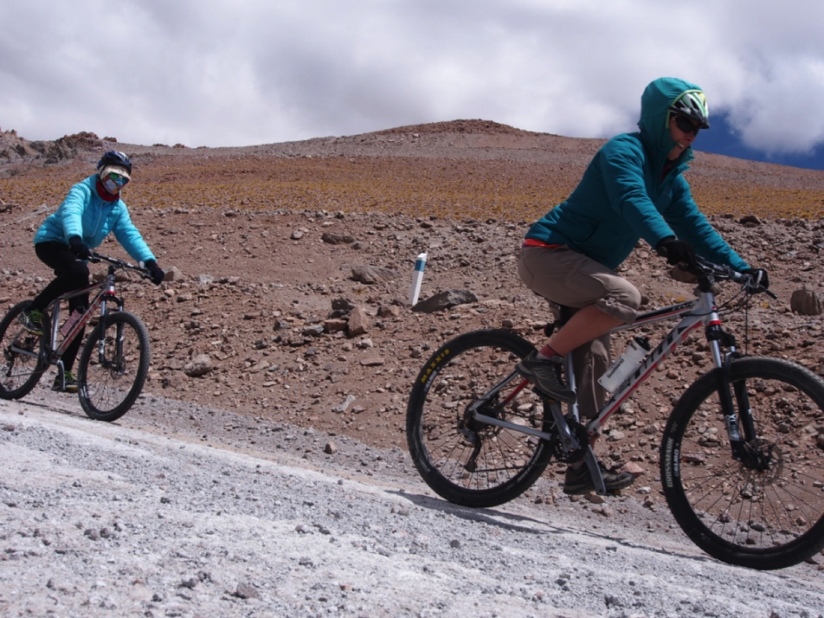
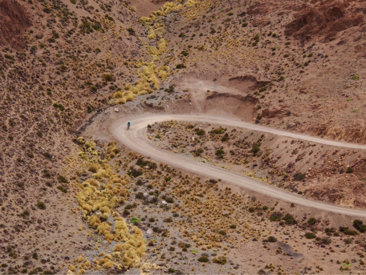
To document the start of the ride, I set up a spot to take pictures of the group of gals heading out on the first portion at the top. Each of them headed out with determined looks and smiles on their faces. It seemed like we were on top of the world. As they pedaled away from me and began spiraling down the switchbacks, I began to realize the enormity of the slopes in front of me and the span of the distance we would cover that afternoon. Long hairpin curves carved into the mountain, almost elegant in their length. Each rider moved smoothly across the terrain like a stitch in time hemming their way into the fabric of the mountain. The red or blue of their coats and helmets added splashes of color against the terra-cotta landscape. One by one, a dot of red or blue rounded a corner where melting snow gave way to a “vega,” a linear patch of green grass that bloomed up the side of the mountain. And then they were gone from my sight. The dots disappeared into the fabric. It was time to get on the bike. The endorphins had kicked in.
My first inclination was to rocket down the trail. A long fast downhill, fun, right?! Then, my oxygen deprived brain cells communicated, the 6,000-foot drop of elevation will be about 3x as long as any continuous mountain downhill I’ve descended in California or Colorado before. That will take some time. In fact, Ana had mentioned that the length of the ride would be somewhere between 3-4 hours until reaching the village of La Poma in the valley.
Reveling in the crisp mountain air, I didn’t realize the cold although my full finger gloves helped as well as the multiple layers on my body. The “survivalist” gear in me checked in from time to time so that I rolled slowly enough to take in the beauty of the panoramic view and colors of the changing landscape without careening over the side. I was riding past millions of years of rock formations, striations of red, rusty orange, mauve and gray painted mountain formations. For me, this was time travel at its best.
However, I didn’t want to get too carried away. Taking a turn too fast would plant me permanently in the vista. So I pedaled close to the mountainside with just enough quickness to feel the breeze brush my face. Sometimes I bumped over baby head size rocks and let my back tire slide out a bit. The road/trail was not technical for intermediate mountain bikers, but it was more of a mental challenge at altitude knowing that a slip could have bad results.
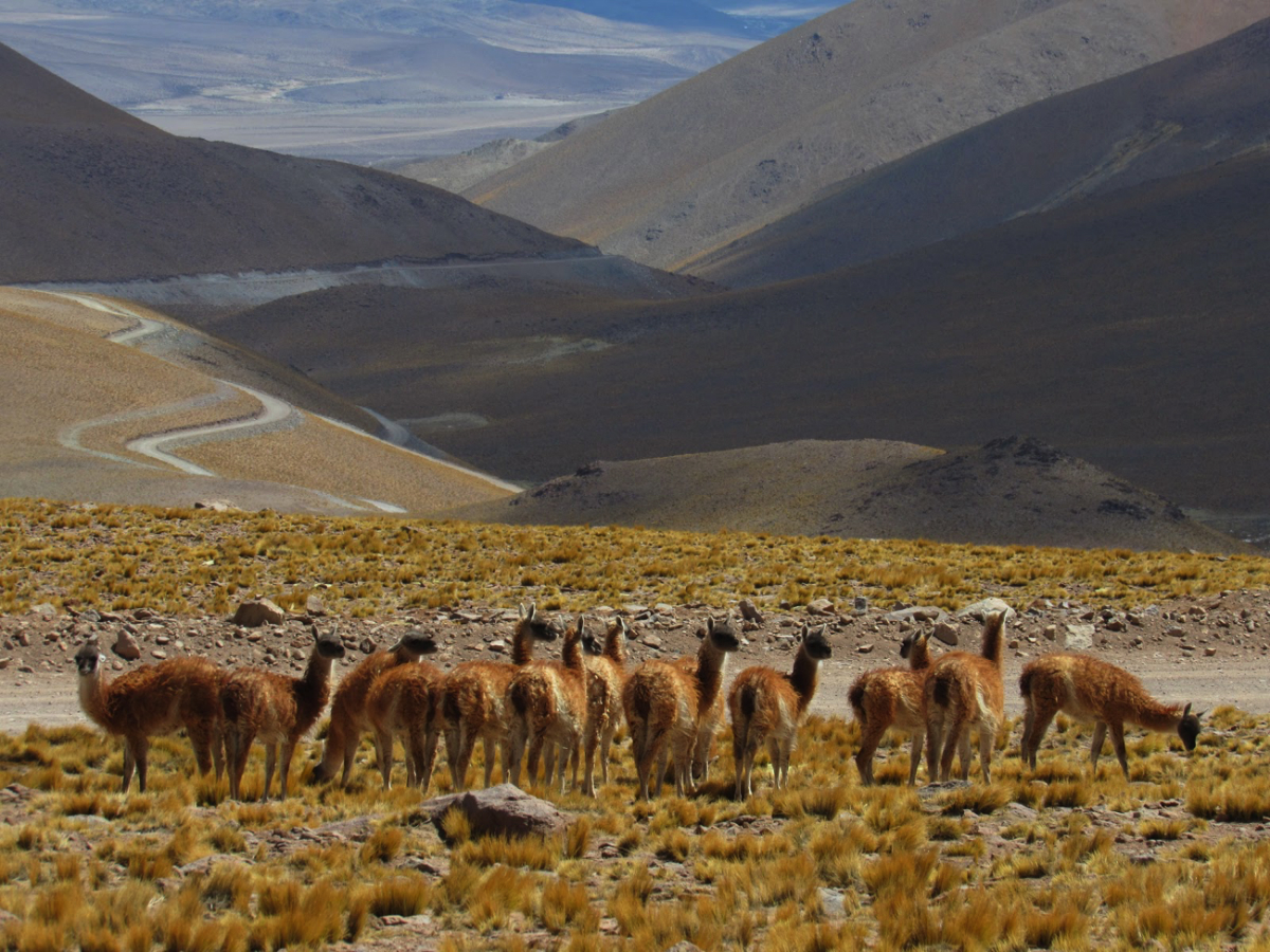
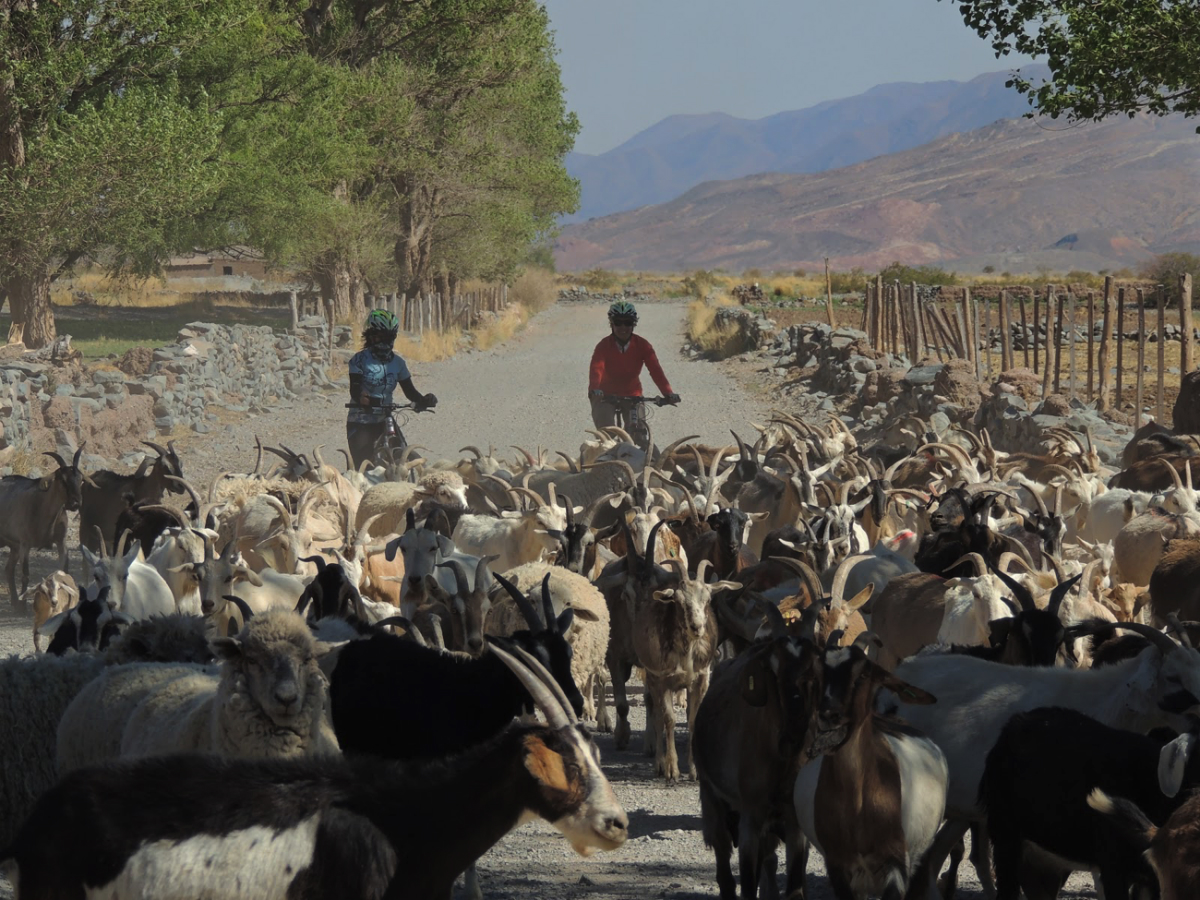
The chance of Vertigo rearing its ugly head was definitely a factor while blitzing down a mountain trail especially in the Andes where mountain peaks average in around 14,000 feet to 18,000 feet and higher. But somehow the beauty overtook any fear of sheer heights. At every twist and turn there was something to see including wildlife: vicunas near the top and llamas quenching their thirst along the mid-mountain streams to the massive herds of goats and lambs crossing the road at the village near the end of our ride.
With the group way ahead of me, I had the road and the view to myself. At times it felt like I was flying, like a giant condor taking in the thermals spiraling down Abra del Acay. There was a great sense of freedom and euphoria that fueled my legs and lungs so that I never wanted to stop even upon finally reaching my group as the rocky mountainsides gave way to the first of many stream crossings towards the greener valley below. I wasn’t alone in my feelings of gratitude at discovering such overwhelming beauty. I think we all were greatly overwhelmed. Our spirits were full with the achievement of completing the ride, and our hearts were full of gratitude for the ability to access such a unique place.
Ann Souter, one of the women in my group defined the day’s ride perfectly, “I was in awe of how beautiful the landscape was and although not a religious person it was one of those moments where you either look to the heavens or to Pachamama with a tip of the hat on a job well done at creating this amazing place.”
Visit www.adventure-landscape.com for more information on how to discover the Argentine Andes and Abra del Acay.